
Canton de Fermains
Boundary
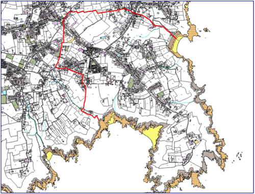
From the Rectory, along main road (Rue au Prêtre) and over the Camps du Moulin to the top of the Rue Jacque Guille, through the Ruette Rabey and down the Water Lane to Moulin Huet bay. From here by way of the cliffs to Fermain bay, up the lane, along the Route Sausmarez and back to the Rectory, taking in Les Blanches Pierre Lane. (Please view the map).
| Abreuveurs | |||
| 22 | Ville Amphré | Fountain and drinking trough | |
| 23 | Le Vallon (Fountain du Hurel) | Pump and drinking trough | The approach thereto must be kept in repair for the use of the public, by the Proprietor of La Vallon and his heirs, who also has in charge the maintenance of the Hurel hill. See ‘actes’ of the Royal Court, dated July 23 1828, March 24, 1829 and January 12,1832 |
| 24 | Courtes Falaises | Fountain and drinking trough | |
| Petit Port | Fountain on slipway | No longer in existence! | |
| Jerbourg | Fountain Cocqerel, near gravel pits overlooking Petit Port | No longer in existence! | |
| Jerbourg (La Moye) | Fountain | No longer in existence! | |
| Jerbourg (Mont au Nord) | Fountain Ricquart | No longer in existence! | |
| 29 | La Bouvée | Fountain and drinking trough | |
| 30 | Calais (Gypsy lane) | Fountains and drinking troughs | |
| 31 | Le Varclin | Fountain | And approach |
| 32 | Les Maindonnaux | Drinking trough | |
| Other Property | ||
| Gate near the Cuckoo rock, one at the Courtes Falaises, and one at Le Mont Durand | ||
| Cliffs | Proprietors of land bordering the cliff must keep the walls in repair.
NOTE: – A seat near the Cuckoo rock, overlooking Moulin Huet bay, belongs to and is maintained by the Propietors of Le Vallon, who has also to keep in repair the roadway between the Cuckoo-rock gate and that at the Coutres Falaises. |
|
Hire the Parish Hall!
Did you know that you can hire the Parish Hall for public and domestic functions such as a wedding reception or anniversary party?